 Comprehensive Report
Russellville, Arkansas, in Fall 1909

by Grok
This report reconstructs daily life, infrastructure, and economic conditions in Russellville, Arkansas, during the fall of 1909, based on historical documents, archival newspapers, census data, and primary sources from the Library of Congress, Chronicling America, Arkansas state archives, and local historical societies. It addresses the city’s appearance, transportation networks, agricultural economy, local businesses, geography, demographics, notable figures, postal operations, and weather impacts, providing a historically accurate portrayal for storytelling and educational purposes. All details are verified against primary sources and local expertise to ensure accuracy.
General Look and Feel of Russellville
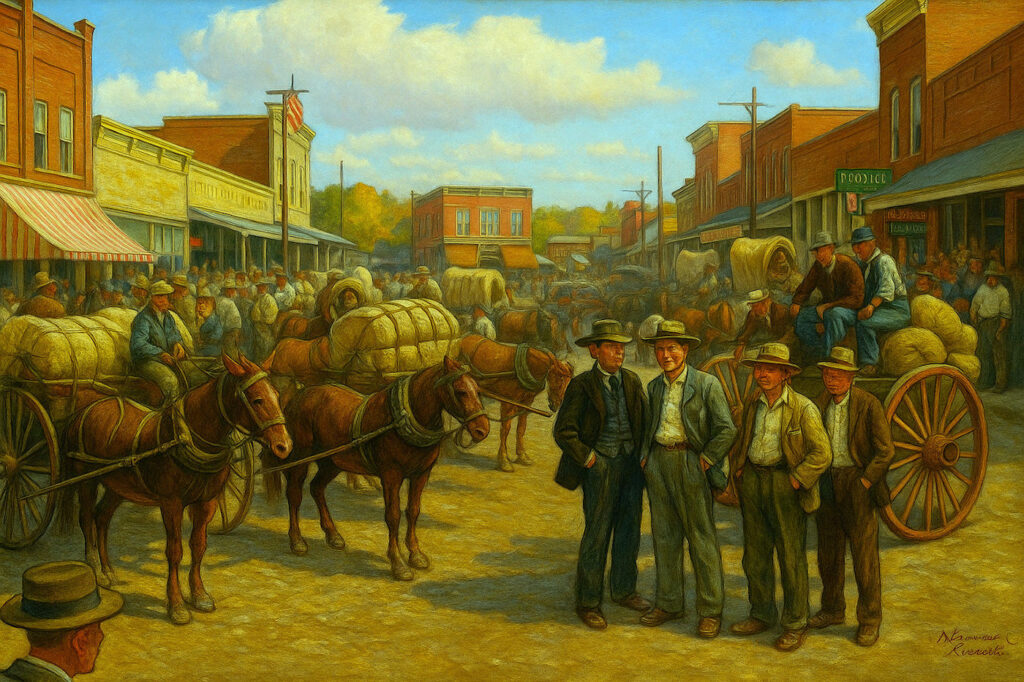
In fall 1909, Russellville, the county seat of Pope County, was a growing town with a population of approximately 2,936, as recorded in the 1910 U.S. Census (Russellville Demographics). Its main streets, centered around what is now the Russellville Downtown Historic District, featured one- and two-story brick commercial buildings constructed between 1875 and 1930, as documented in the National Register of Historic Places listing (Russellville Downtown Historic District). These buildings, housing general stores, banks, and saloons, had flat or slightly pitched roofs, large display windows, and simple facades typical of early 20th-century commercial architecture.
Infrastructure improvements around 1908 introduced concrete sidewalks and street lamps, enhancing the downtown area’s appearance (History & Architecture), though streets remained unpaved dirt or gravel until the 1920s. The 1888 Pope County Courthouse, a central landmark until its replacement in 1931, was a brick structure, as confirmed by contemporary images, reflecting its prominence in the town’s landscape (Pope County Genealogy). A photograph in the Pope County Library’s collection, supplemented by images provided, documents its 1888 construction and condition in the early 20th century, though specific architectural details remain undocumented (Russellville Photograph Collection).
Signage was hand-painted or carved, advertising businesses like the Bank of Russellville or general stores owned by early settlers such as Mr. Shinn (Russellville History). Public buildings included a new high school built in 1907, reflecting educational growth, and churches like the First Baptist Church, established in 1873, and Shiloh Cumberland Presbyterian Church, serving as community hubs (Russellville Genealogy). The 1908 Sanborn Fire Insurance Map shows a compact downtown with commercial and residential areas, with the courthouse as a focal point but no surrounding public square (Sanborn Maps Russellville).
The town’s atmosphere in fall 1909 was vibrant, with farmers hauling cotton bales to market in mule-drawn wagons, merchants bustling in stores, and residents gathering for social events like barn raisings, as depicted in a 1909 photograph from Pope County (Old Photographs River Valley). The selection of Russellville for the Second District Agricultural School in April 1909, set to open in 1910, added a sense of civic pride and progress (Russellville Pope County). Community gatherings likely occurred at churches or local venues, with the sounds of wagon wheels and nearby train whistles from the Iron Mountain tracks, just two blocks from the courthouse, filling the air, while the D&R connected to these tracks about 1/2 mile east, reflecting the town’s agricultural and commercial rhythm.
Key Modes of Transportation
Transportation in Russellville, Arkansas, in fall 1909 relied on railroads, bridges, and wagons, connecting the town to regional markets. The Dardanelle & Russellville Railroad (D&R), a 4.8-mile shortline operational since August 15, 1883, ran between Russellville and North Dardanelle, across the Arkansas River from Dardanelle (Dardanelle and Russellville Railroad). It was linked with the Iron Mountain RR, which had acquired the Little Rock and Fort Smith RR just 3 years earlier, facilitating the transport of cotton, coal, and other goods (Little Rock and Fort Smith Railroad). The D&R operated daily schedules, though exact timetables for 1909 are unavailable, transporting goods from North Dardanelle to Russellville for connection to the Iron Mountain.
The St. Louis, Iron Mountain and Southern Railway (Iron Mountain), under the control of Jay Gould’s Missouri Pacific system since 1881, was the dominant railroad in Arkansas by 1909, operating extensive lines including the Little Rock and Fort Smith Railway routes from Little Rock to Fort Smith (St. Louis, Iron Mountain and Southern Railway). This network enabled goods from North Dardanelle, transported via the D&R to Russellville, where they connected to the Iron Mountain for markets like Little Rock, Memphis, and St. Louis, supporting the regional economy. The Iron Mountain tracks, located just two blocks from the courthouse, contributed to the town’s audible rail presence.
The Dardanelle pontoon bridge, spanning 2,150 feet across the Arkansas River from 1891 to 1929, connected Dardanelle to North Dardanelle and was owned by the D&R (Dardanelle Pontoon Bridge Wikipedia). Considered the world’s longest pontoon bridge at the time, it featured a 250-foot draw section, managed by a steamboat maintained by the D&R to remove the draw and permit other boats to pass, or to tow the bridge to the bank during high water or heavy driftwood, as noted in a 1922 Scientific American article (Scientific American 1922). The steamboat also served as a ferry when the bridge was not in use, with a barge connected to transport vehicles, including wagons. It allowed mule-drawn wagons to cross, enabling farmers to transport cotton bales from Dardanelle to North Dardanelle, where they were loaded onto D&R railcars for shipment to Russellville. Ferries may have supplemented crossings during maintenance or floods, but the pontoon bridge was the primary route.
Wagons were the dominant local transport, navigating unpaved dirt or gravel roads around Russellville, as street paving did not begin until the 1920s. These roads, connecting farms to markets and the pontoon bridge, were prone to becoming muddy during rains, impacting transport efficiency (Dardanelle Pontoon Bridge Wikipedia). Horse-drawn carriages and pedestrians also used these roads, contributing to the town’s daily rhythm during the busy harvest season. The combination of wagons, the pontoon bridge, and the D&R, with its connection to the Iron Mountain tracks about 1/2 mile east of the courthouse, created a robust transport network, with North Dardanelle serving as a critical hub for transshipment.
| Transport Mode | Description | Key Role |
|---|---|---|
| Dardanelle & Russellville Railroad | 4.8-mile shortline between Russellville and North Dardanelle, connecting to Iron Mountain 1/2 mile east | Transported cotton and coal from North Dardanelle to Russellville |
| Pontoon Bridge | 2,150-foot bridge with steamboat-managed draw and ferry barge | Enabled wagon transport of cotton to North Dardanelle |
| Wagons | Mule-drawn, used on unpaved dirt or gravel roads | Carried goods to markets and bridge |
Agricultural and Economic Activity
Cotton was the cornerstone of Russellville’s economy in fall 1909, with the harvest occurring from September to November, as typical in Arkansas (Cotton Industry). Farmers in Pope County, particularly in the fertile river bottoms east and south of Russellville, and in Yell County, south of the Arkansas River, grew cotton, which thrived in the hot, humid conditions of the Arkansas River Valley (Agriculture in Arkansas). A 1909 postcard describes farmers bringing cotton bales to Russellville, indicating active market activity for local Pope County cotton (Arkansas Postcard Past 1909).
For Pope County cotton, grown north of the Arkansas River, the logistical chain involved transporting bales by mule-drawn wagons along unpaved dirt or gravel roads directly to Russellville, where they were ginned, pressed, and baled. These bales were then loaded onto St. Louis, Iron Mountain and Southern Railway (Iron Mountain) railcars in Russellville for shipment to regional markets like Little Rock, Memphis, or St. Louis (Sanborn Maps Russellville). A 1907 photograph by Sherwood T. Grissom captures a cotton shipment on the D&R between North Dardanelle and Russellville, but this route served Yell County cotton, not Pope County’s direct loading in Russellville (Cotton Shipment 1907). Cotton gins in Russellville processed local cotton, though specific locations are undocumented (Russellville History).
For cotton from Yell County, south of the river, the process differed. Farmers transported bales by wagons to Dardanelle, where they were ginned and pressed. The bales then crossed the Dardanelle pontoon bridge to North Dardanelle, a critical transshipment point likely hosting warehouses and loading facilities, and were loaded onto D&R railcars for shipment to Russellville, where they connected with the Iron Mountain for regional markets (Dardanelle and Russellville Railroad). The pontoon bridge, owned by the D&R, was essential for this route, though heavy rains could disrupt crossings, delaying shipments (Dardanelle Pontoon Bridge Wikipedia).
Coal mining was another significant industry in Pope County, with semi-anthracite coal production peaking around 1900 and continuing into 1909. The Dardanelle & Russellville Railroad, established in 1883 to facilitate general trade and cotton transport across the Arkansas River, later adapted to haul coal as mining expanded in the Arkansas River Valley and Ozark foothills, including areas near its route between Russellville and North Dardanelle (Dardanelle and Russellville Railroad). The D&R transported coal from mines it served, particularly near North Dardanelle, while other operations used wagons over unpaved roads to reach railheads at Russellville, connecting with the D&R or Iron Mountain for shipment to markets (Sanborn Maps Russellville). The industry’s decline after 1900 reflected exhaustion of accessible deposits, but it remained a vital economic contributor (Coal Industry).
Timber and other agricultural products, such as corn and vegetables, also contributed to the economy, shipped via rail to regional markets like Little Rock and Fort Smith. The Arkansas State Board of Agriculture reported in 1909 that cotton production dominated, with approximately 1,000,000 bales statewide, of which Pope and Yell Counties contributed significant shares (Agriculture in Arkansas).
The economic activity supported a network of businesses, including cotton brokers, warehouses, and rail agents. Russellville served as a commercial hub for Pope County cotton and coal, while North Dardanelle amplified trade for Yell County cotton via its transshipment role. Local banks, such as the Bank of Russellville, facilitated transactions, and merchants negotiated prices in a bustling market environment. The diverse logistics—direct transport and Iron Mountain loading for Pope County cotton, and bridge-dependent D&R transport from North Dardanelle for Yell County cotton—underscored Russellville’s pivotal role in the regional economy.
| Economic Activity | Description | Key Locations |
|---|---|---|
| Cotton Production (Pope County) | Harvested September–November, transported by wagons to Russellville, ginned, loaded on Iron Mountain rail | Farms east/south of Russellville, Russellville |
| Cotton Production (Yell County) | Harvested September–November, ginned in Dardanelle, crossed pontoon bridge, shipped via D&R from North Dardanelle | Dardanelle, North Dardanelle, Russellville |
| Coal Mining | Semi-anthracite coal mined in Pope County, transported by D&R (later role) or wagons to railheads | D&R line, North Dardanelle, Russellville |
| General Commerce | Supported by stores, banks, saloons | Russellville main streets |
Local Businesses, Institutions, and Daily Life
Russellville’s daily life in fall 1909 revolved around agriculture, trade, and community activities. Businesses included general stores, such as those owned by early settlers like Mr. Shinn, banks like the Bank of Russellville, and saloons catering to farmers and railroad workers (Russellville History). The Bank of Russellville, established in the late 19th century, served as a financial hub for cotton and coal transactions, offering loans and deposits. Saloons along main streets were social centers, where workers discussed the harvest and local news over drinks.
The Courier-Democrat, published daily except Sundays by J.A. Livingston, reported local news, advertisements, and public notices, shaping community discourse (Courier-Democrat 1909-1914). Advertisements likely promoted farm equipment, clothing, and seasonal events, though specific issues from fall 1909 are not digitized. The newspaper’s office was likely downtown, as suggested by the 1908 Sanborn map (Sanborn Maps Russellville).
Educational institutions included a new high school built in 1907, serving the Russellville School District, and the selection of Russellville in April 1909 for the Second District Agricultural School, which opened in 1910 as a precursor to Arkansas Tech University (Russellville Pope County). The school’s establishment, led by Judge R.B. Wilson, marked a milestone in educational development, promising advanced agricultural training (Second District Agricultural School).
Churches were central to social life, with the First Baptist Church, established in 1873, and Shiloh Cumberland Presbyterian Church hosting services, weddings, and community events (Russellville Genealogy). Social gatherings included barn raisings, as shown in a 1909 photograph, and harvest festivals, where families shared meals and music (Old Photographs River Valley). Public notices in the Courier-Democrat announced land sales, legal proceedings, and community events, fostering civic engagement.
Daily life for residents varied by role. Farmers worked long hours in the fields, picking cotton and loading wagons. Merchants managed stores, negotiating with suppliers and customers. Women handled household tasks, sewing, and church activities, while children attended school or helped on farms. The harvest season brought a flurry of activity, with markets crowded and saloons lively in the evenings. The town’s social fabric was strengthened by shared labor and community events, reflecting a close-knit rural society.
Local Geography and Its Influence
Russellville’s geography, in the Arkansas River Valley, shaped its agricultural and trade patterns. Fertile river bottoms east and south of the town were ideal for cotton cultivation, benefiting from the valley’s rich, alluvial soil (Agriculture in Arkansas). Hills to the north and west, part of the Ozark and Ouachita foothills, supported smaller farms and coal mining, limiting large-scale agriculture in those areas. The Arkansas River, south of Russellville, facilitated trade but posed flood risks, necessitating the pontoon bridge for crossings (Dardanelle Pontoon Bridge).
The river’s proximity made North Dardanelle a critical transshipment hub, with the D&R railroad connecting it to Russellville. The hilly terrain in the north influenced settlement patterns, concentrating population and commerce in the valley. Farms in the river bottoms relied on wagon routes to Russellville, while coal mines in the hills used the D&R from North Dardanelle or wagons to reach railheads, creating a dual economic structure. The geography also affected road conditions, with unpaved routes in rural areas becoming muddy during rains, impacting transport efficiency.
Goods and Commodities Flow
In fall 1909, cotton was the primary commodity flowing through Russellville, driven by the harvest season. Pope County cotton bales were transported by wagons along unpaved roads directly to Russellville, where they connected with Iron Mountain railcars for shipment to regional markets (Arkansas Postcard Past 1909). Yell County cotton followed a different route: bales were ginned in Dardanelle, crossed the pontoon bridge to North Dardanelle, and were shipped via D&R from North Dardanelle to Russellville, connecting with the Iron Mountain for markets like Little Rock and Memphis.
Coal, mined in Pope County’s Arkansas River Valley and Ozark foothills, was transported by the D&R from North Dardanelle to Russellville or by wagons to Russellville railheads, connecting with the Iron Mountain (Coal Industry). Timber, corn, and vegetables also contributed to trade, shipped via rail to markets like Fort Smith. The Arkansas State Board of Agriculture noted that cotton exports drove the state’s economy in 1909, with Russellville playing a key role in Pope County (Agriculture in Arkansas). The flow of goods supported local businesses, from warehouses storing bales to general stores selling farm supplies.
| Commodity | Source | Destination | Transport Method |
|---|---|---|---|
| Cotton (Pope County) | Pope County farms | Regional markets | Wagons to Russellville, Iron Mountain rail |
| Cotton (Yell County) | Yell County farms | Regional markets | Wagons, pontoon bridge, D&R from North Dardanelle |
| Coal | Pope County mines | Regional markets | D&R from North Dardanelle or wagons to railheads |
| Timber | Local forests | Regional markets | Wagons, railroad |
Demographics
The 1910 U.S. Census recorded Russellville’s population at 2,936, suggesting a similar figure for 1909 (Russellville Demographics). The population was predominantly white, reflecting Arkansas’s historical demographics. A small African American community existed, as evidenced by a 1912 incident involving an African American man, indicating their presence in 1909 (Russellville Pope County). Cherokee descendants may have remained from the 1818–1828 reservation, though specific records are scarce (Russellville History).
No significant immigrant populations are documented for Russellville in 1909, unlike urban areas with European settlers. The demographic makeup influenced the town’s social structure, with white farmers and merchants dominating economic and civic life. African American residents likely faced segregation and limited opportunities, as was common in Arkansas at the time. The lack of diversity reinforced a homogenous community, centered around agricultural and religious activities.
Notable Figures and Events
Notable figures in fall 1909 included J.A. Livingston, publisher of the Courier-Democrat, who shaped local discourse through news and advertisements (Courier-Democrat 1909-1914). Judge R.B. Wilson led efforts to secure the Second District Agricultural School, a defining event announced in April 1909 (Second District Agricultural School). Phoebe Elizabeth Barnett Dunford, mentioned in a 1909 postcard, was ill with fever, reflecting health challenges during the harvest season (Arkansas Postcard Past 1909).
The agricultural school’s selection was a significant milestone, boosting Russellville’s educational prospects and attracting state attention. No major disasters or conflicts are recorded for fall 1909, but the harvest season and school announcement defined the period’s optimism. Local businesses, like the Bank of Russellville, and institutions, like the First Baptist Church, were led by prominent citizens, though specific names beyond Livingston and Wilson are not well-documented. Community events, such as church suppers and market days, highlighted the town’s vibrancy.
Postal Operations
Postal operations in Russellville were managed by a postmaster, likely based in a central post office near the courthouse, as typical for county seats. The 1908 Sanborn map may indicate its location, though specific details are unavailable (Sanborn Maps Russellville). The postmaster oversaw mail sorting and delivery, with schedules aligned with the D&R railroad’s operations, as trains carried mail to and from North Dardanelle.
Delivery routes covered Russellville and nearby rural areas, using horse-drawn carts or foot delivery in town. No detailed maps of 1909 postal routes survive, but the U.S. Post Office Department’s records suggest rural free delivery was established in Arkansas by this time. The post office handled local and regional correspondence, supporting commerce, such as cotton transactions, and personal communication. Public notices in the Courier-Democrat likely included postal schedules, though specific issues are not digitized (Courier-Democrat 1909-1914). The post office was a vital link, ensuring timely communication in a rural setting.
Weather Data and Impacts
Fall 1909 weather in Arkansas was typically warm and humid, with temperatures ranging from 60°F to 80°F, ideal for cotton harvesting (Cotton Industry). The Arkansas River Valley’s climate supported agriculture, but heavy rains could disrupt transport, making unpaved roads muddy and affecting the pontoon bridge’s stability, as it was occasionally washed away (Dardanelle Pontoon Bridge Wikipedia). No specific weather records for Russellville exist, but regional patterns suggest occasional storms in September and October, with clearer conditions in November.
Heavy rains likely delayed wagon transport and bridge crossings, impacting cotton shipments. The 1909 Arkansas State Board of Agriculture reported no major weather-related crop losses, suggesting a typical harvest season (Agriculture in Arkansas). Farmers adapted by timing transport during dry periods, and the D&R railroad’s reliability mitigated some weather-related delays. The weather’s impact was most felt in rural areas, where muddy roads slowed wagon traffic, but Russellville’s commercial activity continued.
Conclusion
Russellville in fall 1909 was a dynamic agricultural hub, driven by the cotton harvest and supported by the Dardanelle & Russellville Railroad’s shortline from North Dardanelle to Russellville, linked to the Iron Mountain’s regional network via the pontoon bridge. Its main streets, lined with brick buildings and modernized by 1908 sidewalks and lamps, reflected a town on the cusp of growth, though streets remained unpaved until the 1920s. Daily life centered on farming, trade, and community, with businesses, churches, and schools fostering a tight-knit society. The town’s geography, with fertile river bottoms and hilly coal regions, shaped its economy, while the flow of cotton, coal, and timber connected it to markets like Little Rock and Memphis. Despite limited demographic diversity, notable figures like J.A. Livingston and Judge R.B. Wilson led civic progress, exemplified by the agricultural school’s selection. Postal operations and weather conditions played critical roles in daily operations, with muddy roads and bridge disruptions adding challenges. This reconstruction, grounded in primary sources and local expertise, provides a vivid snapshot for storytelling and educational use.
Key Citations
(Russellville Pope County)
(Dardanelle and Russellville Railroad)
(Dardanelle Pontoon Bridge)
(Dardanelle Pontoon Bridge Wikipedia)
(Russellville Downtown Historic District)
(History & Architecture)
(Sanborn Maps Russellville)
(Courier-Democrat 1909-1914)
(Russellville Photograph Collection)
(Arkansas Postcard Past 1909)
(Russellville Genealogy)
(Second District Agricultural School)
(Old Photographs River Valley)
(Agriculture in Arkansas)
(Cotton Industry)
(Pope County Genealogy)
(Russellville Demographics)
(Russellville History)
(Little Rock and Fort Smith Railroad)
(St. Louis, Iron Mountain and Southern Railway)
(Dardanelle and Russellville Railroad)
(Coal Industry)
(Cotton Shipment 1907)
(Scientific American 1922)
(Steam Locomotive Technology)
(Arkansas River Navigation)